The Map Inside: Connecticut Officials: 1972
This exhibit shows how the Connecticut official tourist map has changed since the 1930s. You can start with the introduction or browse year to year. The scans may not be actual size (150 dpi), but are consistent with each other.
Other years:
1930
1934
1935
1938
1941
1942
1943
1949
1952
1955
1956
1957
1959
1960
1961
1963
1965
1971
1972
1975
1989
1998
2000
2001
2002
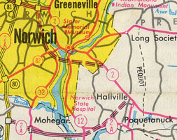
Connecticut used the same design for the 1960s maps into the late 1970s. This map shows a proposed Norwich inner belt for Route 2 as well as the proposed extension of Route 2A. Curiously, the Route 2 proposal was not depicted on the more detailed Norwich inset.
Route 2A in 1972 is actually a "Super 2" (2-lane undivided access controlled) route, and is shown in later maps with a single red line/black outline instead of double.
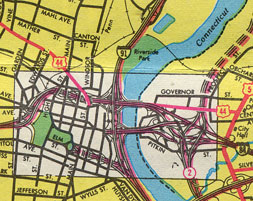
Unfortunately, the color printing is misaligned, but you can still see the fine detail and level of workmanship that stayed for almost 30 years. Ramps are single hairlines, and multilane ramps (or separate roadways of a freeway) are red lines with black outline. The white area is shown separately in even more detail. (see 1975 map).
The proposed freeway alongside Prospect Street is the now-cancelled Interstate 284.