The Map Inside: Connecticut Officials: 1934
This exhibit shows how the Connecticut official tourist map has changed since the 1930s. You can start with the introduction or browse year to year. The scans may not be actual size (150 dpi), but are consistent with each other.
Other years:
1930
1934
1935
1938
1941
1942
1943
1949
1952
1955
1956
1957
1959
1960
1961
1963
1965
1971
1972
1975
1989
1998
2000
2001
2002
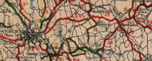
State maps did not include city insets until 1941, so we instead show a double-wide main map sample of the Danbury area. You would expect Interstate 84 not to make an appearance here, but even US 202 is missing: it and US 44 were commissioned the following year.
The map appears to have been printed in five passes: black roads and town names, blue bodies of water, and three types of improved road. Red lines are trunk line highways, green lines state aid, and brown lines other improved roads. As in the contemporary National Survey maps of New England, route numbers are written beside the road instead of in markers.
Brown numerals, such as "228" above Danbury center, are not route numbers, but location numbers, keyed to a table at the bottom of the map.