The Map Inside: Connecticut Officials: 1971
This exhibit shows how the Connecticut official tourist map has changed since the 1930s. You can start with the introduction or browse year to year. The scans may not be actual size (150 dpi), but are consistent with each other.
Other years:
1930
1934
1935
1938
1941
1942
1943
1949
1952
1955
1956
1957
1959
1960
1961
1963
1965
1971
1972
1975
1989
1998
2000
2001
2002
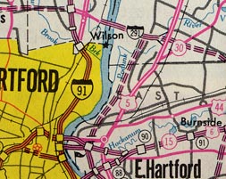
This scan includes a good assortment of road types: undivided; divided with partial access control (like US 5); freeway (like I-91); and proposed freeway (I-291, I-284, and I-86).
The completed section of I-291, from the Bissell Bridge to US 5, was signed state route 291 at the time. A rarity in maps of this era is the interchange detail at CT 291 and US 5; almost all interchanges at this scale are depicted as squares (complete) or small rectangles (incomplete).
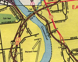
Classic ConnDOT city inset cartography here: fine lines for interchange detail, thicker lines for freeway mainlines, separated as needed for the frequent left exits. Shown is part of East Hartford and the south meadows of Hartford.
Some points of interest in 1971: Route 17 designated along Main Street and overlapping with Route 2 into Glastonbury; old configuration of the Charter Oak Bridge approach and cloverleaf at Main Street; and the old configuration of the northern I-91/Route 15 diverge. The white area at top is further expanded into more detail. See the 1975 map for an example.