There are 226 "secret" routes in Connecticut: highways with numbers above 400.

"Secret" is just an unofficial term for unsignposted state roads and state service roads. Many of these are small auxiliary roads, or even long exit ramps.

The general public should never hear about secret routes, but they sometimes show up on maps, and a few road signs have even gone up.

This page discusses some of the more interesting routes in the 800s. These are mainly in DOT District 4: western and northwestern Connecticut.

See also: selected 400's, selected 500's, selected 600's, selected 700's, selected 900's, or the complete list (400-1001).

800

SR 800, part of the old Route 8, is not only the state's longest unsigned route, but is also the only unsigned route that overlaps any other numbered route (in its case, US 202 for 0.06 miles). Since these routes aren't signed, there's little need to continue them across overlaps for continuity.

805
  • Length 2.76 miles
  • From White Street (old US 6), Danbury
  • To US 202 in Brookfield

Federal Road was the original US 7 before the freeway portion opened here in 1977, and is also known as "old Route 7". Part of Federal Road was widened in 1997, and most of it is four lanes wide.

Even with US 7 relieving through traffic, Federal Road serves significant business and retail traffic. A goal of the Housatonic Valley Council of Elected Officials (HVCEO) is to improve intersections throughout, and widen to a consistent profile of four through lanes plus turning lanes from Starr Road northward to the Brookfield town line.

806
  • Length 1.54 miles
  • From White Street (old US 6), Danbury
  • To I-84 exit 8 in Danbury

Newtown Road here was part of the original US 6 before I-84 opened in 1961, and is also known as "Old Route 6." SR 805 (old Route 7) comes close to intersecting SR 806, but is a few blocks to the west.

The portion of SR 806 between Plumtrees Road and exit 8 was widened to four lanes in 1991. Traffic volumes justify widening the rest of SR 806 as well, but this would cause problems at the intersection with Triangle St, Cross St, and Beaver Brook Road. Currently, the city of Danbury and the Housatonic Valley Council of Elected Officials (HVCEO) call for widening SR 806 to four lanes westward from Plumtrees Road to Old Shelter Rock Road.

820
  • Summary One of a pair of isolated routes in Kent
  • From 1961
  • To 2000

SR 820 and SR 821 were two isolated segments (about 1/3 mile each) of Camps Flat Road in Kent. They didn't connect to any other numbered route (or to each other). They were both part of the old (1930s) Route 130. These routes were under arbitration since the early 1960s route reclassification, meaning the state wanted to delete them from its system, but the town of Kent did not want to take over maintenance. In 2000, both routes were deleted.

Neil Kelly shows how you could tell when you're on former 820 (or 821): the pavement changes (town and state use different pavement); a double yellow centerline appears where there was none before; and you see a small "STATE HIGHWAY BEGINS" sign. At the end, the road reverts to no center line and there's a small "STATE HIGHWAY ENDS" sign. These signs may be gone now.

SR 820 and SR 821 in 1967
Map scan of SR 820 and 821, Kent, 1967
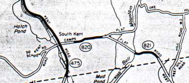
Here's a scan (about 2½ miles wide) from the official ConnDOT 1967 county map. Solid lines are state-maintained roads. The border is the Kent - New Milford town line. US 7 is off-map to the west; US 202, to the east. SR 475 (South Kent Rd) is now called SR 827.
821
  • Summary One of a pair of isolated routes in Kent
  • From 1961
  • To 2000

See description for SR 820, above.

832
  • Summary Sort of signed as US 7A
  • Length 0.32 miles
  • From US 7, North Canaan
  • To Mass. state line

SR 832 is Ashley Falls Rd in North Canaan. This road becomes Mass. Route 7A across the border; at US 7 in Connecticut is a sign pointing to Route 7A along the road. Matthew Currie writes that this used to be part of US 7 before it was rerouted east about 1956:

"Interestingly, the replacement stretch of road from the Canaan Barracks to near Sheffield was built only about a year after a major reconstruction of the old route through Ashley Falls. There is a re-engineered (and for a while 4-lane) stretch of the now nearly abandoned Rte. 7a north of Ashley Falls, which was barely dry by the time it was bypassed. Several new businesses opened up there in about 1955, including a luncheonette that never opened. I don't know who was responsible for this boondoggle, but I remember as a kid of 7 or so, observing all this and wondering why they did it all that way."

840

The genially-named White Turkey Rd Extension parallels both US 7 to the west and a railroad to the right.

The road was proposed in the late 1960s, at the same time the US 7 expressway was being studied. In 1968, the Housatonic Valley Council of Elected Officials (HVCEO) asked ConnDOT to study the feasibility of building a connector from the proposed SR 840 over the railroad tracks to the east. This would provide access from I-84 and US 7 to vacant land zoned for business development.

In 1969, ConnDOT determined that the proposed connector was a worthy idea. SR 840 was later built to accommodate a future "J" shaped bridge connector, starting at-grade, curving to the west for a short time, then rising up over SR 840 and the railroad tracks to the east. The "J" Bridge was built in the early 1990s and carries Riverview Road.

This information is courtesy of Jonathan Chew, HVCEO Executive Director.

860

SR 860 (Wasserman Way) and the east-west portion of SSR 490 comprise the recommended access route from Route 25 to Interstate 84 at exit 11. The proposed four-laning of Route 25 extends from the expressway terminus in Trumbull northward to SR 860 only; beyond this intersection, Route 25 will remain two lanes wide. In late 2001, guide signs on I-84 were revised to recommend exit 11 (Route 34) instead of exit 9 (Route 25) as the best way to points south on Route 25.

860 History

SSR 490 (Mile Hill Rd and Nunnawauk Rd, designated 1991) predates SR 860 and serves the Ward A. Garner Correctional Institution. SR 860 is a newer bypass road through the former Fairfield Hills State Hospital complex, built primarily for east-west access between Route 25 and I-84/Route 34. It was designated on Jan. 4, 1999.

In 1981, Newtown's plan of development called for road changes in the hospital area to provide alternate access between Main Street and I-84. The state and its Department of Mental Health opposed this, and negotiations continued until an agreement was reached in 1991. The road is named after Newtown state representative Julia Wasserman.

As the Route 25 freeway plan is dead, the state plans to dismantle the interchange built for it at I-84 exit 11, and in its place build a conventional diamond interchange. Wasserman Way would be extended eastward across Route 34 to meet I-84 here.

860 Kurumi Suggests

To encourage thru traffic to use this route, give it a signed route number. A natural choice might be Route 225, since it's related to Route 25. Or, Route 25 itself could be rerouted along Wasserman Way, and overlap with I-84 from exit 11 to exit 9; but the 225 choice is less disruptive.

867

SR 867, Clapboard Road, was originally part of Route 67; when a new alignment opened in 1960, Clapboard Road became Route 67A. In 1963, Route 67A became SR 867 and is no longer signed.