
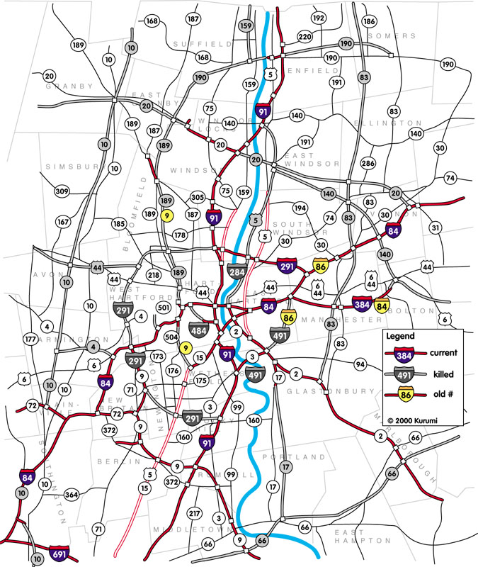
Hartford's Proposed Freeways
Cancelled freeways (gray) in Hartford. See also: entire metro area (242K) For grins: my earlier Hartford map, looks quite amateurish by comparison |
No one, however, can reasonably claim that driving there is boring. Driving on Interstates 84 or 91 probably brings a few questions to the observant driver between lane changes: what where those "Evel Knievel ramps" ending in midair going to connect to? Why is this other interchange only half used? And why, with a metro population of over one million, is there no beltway around downtown Hartford?
I'll briefly explain the cancelled freeways below, and give links to more information. Pop up the big map in a separate window for reference.
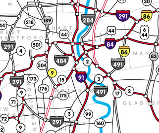
I-291 and I-491
Plans dating back to the late 1950s called for a simple beltway system around the city.
Interstate 491 through East Hartford was part of Connecticut's original 1957 interstate
highway mileage. Interstate 291, serving the other four quadrants of the circumference,
was added later.
I-491 was never built, except for the Putnam Bridge, now part of Route 3 between
Glastonbury and Wethersfield, which opened on New Year's Eve, 1958. East Hartford opposed the highway,
contending that it already had more than its share of freeways slicing across town.
In 1968, the proposed I-491 became part of the proposed I-86 extension. In 1973, funds
for it were traded in for other projects.
I-291 met similar opposition. In the northwest, proximity to reservoirs providing area drinking
water caused concerns about runoff. In the southwest, concerns were over property instead
of pollution. In the early 1970s it became apparent I-291 would not be built west of
I-91. The northeast portion of 291 did open in 1994.
More: I-291, I-491
I-284 and I-484
These were proposed connecting routes. I-484 would have handled I-91 and I-84 connecting
traffic, relieving the incomplete I-91/84 interchange downtown. The existing Whitehead
Highway (built in 1945) would have been extended under Bushnell Park to meet I-84 at
exit 48. I-84's 3-level split at Asylum Avenue was intended to accommodate I-484 ramps.
The Whitehead Highway (secret Route 598)
is exit 29A (Capitol Area) off I-91.
I-284, first proposed as the "relocated Route [U.S.] 5," would have connected the Governor
Street ramp in East Hartford to I-291. More far-reaching plans would extend I-284 up
to East Windsor to meet I-91. Environmental concerns (wetlands) helped kill I-284
in the late 1980s. The Governor street ramps and short highway are officially
secret Route 500.
More: I-284, I-484
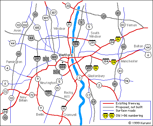
I-84 vs. I-86
I-84's original 1956 route was as it is now, ending at I-90 in Sturbridge.
In the 1960s and 1970s, Connecticut and Rhode Island planned to run I-84 east to Providence
instead. I-84 east of Manchester was rechristened I-86 in late 1968.
However, concerns over the Scituate Reservoir (Providence's water supply) in I-84's path
scuttled the plan, and in 1983 I-84 was moved back. The South Manchester portion of
the old I-84 became I-384.
More: I-84, I-86
US 5
Once proposed as an expressway from I-84 at East Hartford to I-91 at East Windsor,
eliminating the need for some traffic to cross the river twice. The segment south
of I-291 was also proposed as I-284.
Route 10
The state had planned for Route 10 to be upgraded to a freeway from New Haven all the way
to Massachusetts. Several studies were done, but all that was built was
SR 597, the long ramps at I-84 exit 29 in Southington.
More: Route 10
Route 17
A planned extension of the existing Route 17 freeway to a proposed Route 66 freeway
in Portland. A 1960s planning study predicted Route 17 traffic would outweigh
US 7 traffic between Danbury and New Milford.
More: Route 17
Route 20
A Hartford regional planning map proposed extending Route 20 across the river to
eventually meet I-84 near Tolland. Some plans also called for extending 20 westward
to the proposed Route 10 freeway.
More: Route 20
US 44
The idea of a US 44 freeway, which some long-range plans proposed all the way to US 7,
fell out of favor in the 1970s.
More: US 44
Route 83
I haven't seen any actual studies on this one; just lines on some "future needs" planning
maps. Route 83 would have extended into the Springfield metro area.
More: Route 83
Route 140
An early plan connecting Windsor and Bolton, this probably evolved into the Route 20
plan east of the Connecticut River. When Route 140 was shifted in 1963, the planned
freeway alignment drifted even farther from that of the existing road.
More: Route 140
Route 159
A CRCOG plan proposed a freeway from Route 190 to the Springfield area. This would
conceivably have also handled amusement park traffic to Agawam, Mass. The plan didn't show
a number for this route, so I numbered it after the road that would have
shown the most relief: existing Route 159.
Route 189
This highway, starting at Exit 46 on I-84, would have followed the existing Route 189
to the east, connecting to either a Route 10 freeway or Route 20 near Bradley International
Airport. A short freeway section in North Bloomfield, which routes 187 and 189 share,
opened in 1960. The exit 46 ramps are officially SR 503.
More: Route 189
SR 501
The Park Street ramps (I-84 exit 43) would have continued up to about Farmington Avenue
in West Hartford center. I don't know of a planned number for this route.
The existing stub freeway is SR 501.
More: SR 501
SR 504 (old Route 9)
The Flatbush avenue ramps (I-84 exit 45) would have connected with the Berlin Turnpike
near the 314 split in Wethersfield. This was once planned as part of the old planned Route 9
freeway (renumbered to the planned Route 189 freeway in 1963).
The existing stub freeway is SR 504.
More: SR 504, Route 9
How has Hartford really changed over the years? Road Map Collectors of America president Dave Schul once devoted one of his popular MapQuizzes to Hartford maps. Unfortunately, it was a .edu link, and is now gone. If it reappears, I'll let you know.
Meanwhile, see The Map Inside: The Connecticut Officials for some Hartford map scans.
3di's |
Connecticut |
Roads |
Home
![]()
All artwork copyright (c) 2000 Kurumi Design, unless noted.