

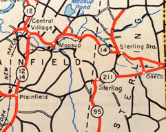
 This 1948 map scan shows how Route 211 seemed to be another number for part of state route 95. In 1950, the portion of Route 211 west of Route 95 became Route 95 Extension / Route 95A.
Route 95A appears to be the same as Route 95 Extension; the ConnDOT spreadsheet uses the former, and its highway logs the latter. In any case, this was the 0.03 miles of Plainfield Pike leading from the Plainfield town line to old Route 95 in Sterling. It's part of Route 14A today.
In 1950, Route 211 in Sterling was decommissioned. State route 95 was extended eastward, replacing most of Route 211, to reach Route 14. The 0.03-mile leftover portion of Route 211, ending at the Plainfield town line, became (in the highway log) Route 95 Extension. This was probably not signed.
The ConnDOT spreadsheet (see "Sources") makes no mention of Route 95 Extension, but does note that in 1959, when Route 95 became Route 49, a road called Route 95A in Plainfield and Sterling became Route 49A. Also in 1959, Route 49A became SR 586, which in 1963 became part of the new Route 14A.
The original Route 211 stopped at the Plainfield town line, but Route 95A/49A apparently entered Plainfield, and must have been extended at some time. I don't know if it reached Route 12.
In other words:
- 1950: small part of CT 211 becomes CT 95 Ext
- 195?: CT 95 Ext becomes CT 95A (or they were always synonymous)
- 195?: CT 95 Ext / 95A is extended west, possibly
- 1959: CT 95A becomes CT 49A, which becomes SR 586
- 1963: SR 586 becomes CT 14A