
Updated Sept 5, 2024
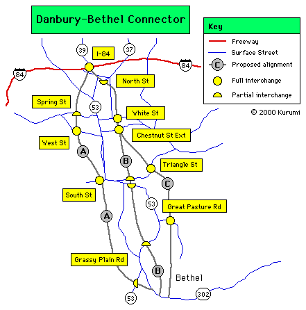 Three alignments for the Danbury-Bethel Connector studied in 1963 report.
Interstate 84 gives Danbury a wider berth than most Connecticut cities enjoy: the highway bypasses the downtown a few miles to the north. As US 7 overlaps I-84 in that area, most freeway service to Danbury and Bethel is from the north as well.
Even before I-84 opened, studies were underway to provide a connecting route to downtown Bethel, serving central Danbury as well. The most ambitious plan was a four-mile, four-lane freeway with five interchanges, which state documents proposed as an extension of Route 58.
However, the plans never came to fruition. The Danbury News-Times states that Patriot Drive, a short street near downtown, was built to be part of the connector in 1976. No plans for the connector are active now.
In the 1950s and 1960s, planners projected large employment and population growth in Connecticut cities and suburbs. Projected traffic for the 1980s and beyond led to over a dozen proposed freeways that eventually were cancelled. In Danbury, the projected problem was congestion on Main Street (Route 53) from Route 302 (then part of US 202) to I-84. The solution would provide relief for that corridor.
In 1956, Bethel State Rep. Mary Reed advocated a bill to design and build a connector to the planned Danbury Bypass (today's I-84, but was conceived as US 6 and US 7 at the time).
In 1957, the state legislature ordered a study of a connector from the Danbury-Bethel town line on the proposed Interstate 84 (near exit 8) to the center of Bethel. This four-lane connector would have at-grade intersections, though the number of accesses would be minimized. However, the study later concluded that the north end was far enough away from the Main Street corridor that neither Danbury nor Bethel would be all that well served.
In 1958, a plan of development was prepared for the city of Danbury. The study recommended a connection from I-84 to central Danbury, extending easterly of Starr Avenue and Rosehill Avenue, and following a reconstructed River Street to end at Elm Street (see diagram).
Also in 1958, the Bethel Town plan included a four-lane "Business Center Bypass" expressway, along with a rectangular loop system around Bethel Center.
A 1961 report by Thomas Walbert and Associates concurred with the Danbury idea, and extended the route through the city center to South Street. The connector would be an expressway from I-84 to West Street, and a boulevard south of there.
In 1961, the legislature ordered another study, this time for a highway starting at the I-84/Route 39 interchange (exit 5), providing connections to downtown Danbury, and ending in downtown Bethel. The state highway commission arrived at three alternatives, all of them expressway treatments, in 1963. The study concluded that Line A (too far west) and Line C (too far east) were less suitable for serving downtown Danbury traffic than the recommended Line B.
The first alternative, Line A, would follow the Walbert route, passing slightly to the west of the city center. Line A would have interchanges at the following locations:
Line A would touch down at Greenwood Avenue (Route 302).
Line B would skirt downtown to the east instead of the west. It would have interchanges at the following locations:
Line B would also touch down at Greenwood Avenue (Route 302).
Line C would veer more to the east, but share some alignment with line B. It would have interchanges at the following locations:
Line C would also touch down at Greenwood Avenue, across the railroad tracks from Line B.
At some later point, a similar freeway from I-84 exit 8 to Maple Avenue in Bethel was studied; as the years progressed, this proposal was called the "East Swamp Connector" and the "Old Sherman Turnpike Extension", the latter named after a street ending a short distance south of US 6 at I-84 exit 8.
Bethel's 1984 update to its plan of development mentioned the need for the connector, but by 1997 the town had determined it was not practical and should not be pursued.
Though the freeway idea has been abandoned, planners are still studying ways to improve access to I-84. One hindrance is the rotary configuration of exit 8 at US 6: Payne Road from Bethel reaches the rotary just counterclockwise of the I-84 eastbound onramp, requiring the driver to travel nearly all the way around the interchange to reach it. In 1982 a new entrance ramp to I-84 eastbound directly across from Payne Road was proposed; in 1989 the state rejected this idea, saying the ramp would be too close to the existing onramp. The 1997 Bethel plan of development recommends moving the existing ramp to Payne Road to make the round-trip unnecessary.