Me and The Roads is at http://www.kurumi.com/roads/matr/.
When MATR starts up, you'll get a small control panel. Press Create to create a new island. When the island's ready, the other buttons will be enabled. If you want to start over, press Create again; MATR will close any window and give you a new island.
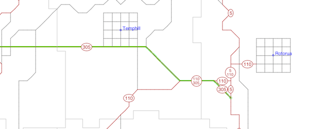
Map
This window contains a scrollable, zoomable road map of your island.
It's pretty cool.
Press + to zoom in 2X, or - to zoom out 2X.
The practical limits to zooming are legibility. If you zoom in too much,
however (so only one grid square is visible) route markers won't appear.
Press fit to resize the map to fill the window as best as it can (the map will always keep a 1:1 aspect ratio, so part of your window will usually be left blank).
If you click on the map, one of several things can happen. You control this on the window's "Mouse Click" selector.
Log
This is the highway log: an inventory of your numbered highways, with a
mileposted list of town line crossings and intersections with other
highways. Most real-life state DOT's have a document like this.
If you've made changes to the highway system, press "Refresh" to see them
on the log.
The Log starts up showing a list of all highways. To list only one highway, type its number in the input area and press Show Route. To list all highways, press Show All.
View
This gives you a 3-D perspective view of any intersection.
It's very rudimentary at this point, showing only grass, sky,
pavement and signs.
To move to a place set the map to "Move Viewer" and click on the map. Set "facing" in the viewer to point the viewer. (Remember, if it's other than north, it's turned around from "up" on the map).
Rename
Use this tool to rename a street or town, or renumber an entire highway.
Although you can use the paver to give stretches of road different names,
the Rename tool is much better for global changes, since it doesn't miss
anything. (Internally, it's more efficient too).
Enter any existing route, street, or town in the appropriate "Old" entry area, and your new name or number in the new. Press Change to apply the new information. If the old name ore number doesn't exist, or the new one already does, the Rename tool won't make the change, and will tell you why.
Neat shortcut: Click the right mouse button on the map to grab a street name, route number, or town: MATR will fill in the Rename panel with what you clicked, saving you some typing.
Paving, naming, and renumbering
Paving in MATR is better than real life: to build a new road,
simply draw its path on the map, decide how wide it should be,
and give it a street name or route number.
No EPA, politicians, bean-counters, scheduling, or public hearings.
In the map frame, set the "Mouse Click" selector to "Pave". The Pave Tools panel will appear. This panel hides itself when you select a different Mouse Click mode on the map. To make it reappear, select Pave mode again.
To renumber an entire route, or rename an entire street, don't use the Pave Tool: instead, use the Rename tool available from the main MATR control panel. This will save you time and memory, and keep your highway system less cluttered.
To do anything in pave mode, you'll first draw a path, to tell MATR where your paving and numbering will take place. Then you'll pave that path to a desired width, and then give it a street name or route number. (Or you can also erase the path, which removes any existing pavement in the path.)
Your path has a start and an end, and a forward direction. This direction helps you specify which way should be called east (for example) on a road that twists and turns.
Drawing a path
When you start MATR, no path is selected. Your first step is always
to locate on the map where you'd like the path to begin.
Set the map to Pave mode (see map, earlier in this page)
To start a selection, click on the map where you'd like it to begin.
MATR will display a small green circle marking the start of the path.
To extend a path, click again (don't drag) somewhere else on the map. MATR will extend a green line from the last point you clicked to this one.
MATR only allows roads in eight directions (45 degrees apart). If your click was exactly 90 degrees or 45 degrees from the last point, MATR will extend the path in a straight line. Otherwise, the connecting line will have one "elbow" in it.
While you're drawing the path, you can still scroll or zoom the map; depending on the zoom level, you can work block to block, or create a long straightaway to the other end of the island. MATR saves your path until you deselect it or quit the program.
If you don't like what's happened with your path so far, MATR provides a helpful "undo" function: just click anywhere on the path you've drawn to shorten it back to that point. If you want to discard the entire path and start over, press Deselect on the Pave Tools panel. (A shortcut for Deselect is to shift-click anywhere on the map).
Figure eights considered harmful
Your path can have as many twists and turns as you like, and can go
anywhere there is land. However, you should avoid creating loops
in any one numbered route or named street.
When MATR maps or logs a route, it needs to find a beginning and an end.
Having a loop won't ruin your layout, but MATR will stop mapping or logging
that route at that point. Once you fix things, MATR will resume handling
that route correctly.
No underwater or illegal intersections
MATR doesn't offer bridges yet, so your path can't cross water.
In addition, you won't be able to create complex or ill-formed
intersections (see table). In order to keep things simpler and smaller
(and faster), MATR deals with the prospect of five-way intersections
by preventing you from creating them.
What happens if your path contains one of the no-no's above? MATR stops paving or numbering at that point. An error message will appear in the Pave Tools panel if this happens. You can then move the path or fix the obstacle and try again.
Paving a new road
To create a new road, first draw a path for it on the map.
Then use the Pave Tools panel to select a pavement type, and press Pave.
The map will show the new road, and leave your path selected.
The road won't have a street name or route number;
your next step will usually be to give the road one or the other.
Naming or numbering a road
To apply a route number, type it with a direction (such as "8 north")
in the top route box. To apply two route numbers, fill in the second
box as well. To apply a street name, type it in the third box.
You can apply any combination of these to a stretch of pavement.
Select "set" from the option menu and press Name.
The map will reflect the new information (except street name.)
You can use n, e, s, and w as abbreviations for directions; so "8 n" means "8 north".
What if the path overlays existing roads? Your path can include segments of already-paved road as well as open space. When you pave, you set the entire path, including the existing road, to that pavement type. The existing road's width is not preserved, but its route numbers and street names are left alone.
When naming or numbering the path, you may want to use the Add option, which adds the new names or numbers to any existing ones. The Set button mentioned above will overwrite any existing information.
Highway Engineer's Playbook
Here's how to do some common highway engineering tasks.
Widening an existing road
You can widen or narrow an existing road, without affecting its name
or route number.
Select a path over the road. Select a pavement type, and press Pave.
The map will show the new pavement type.
Adding a route number to a road
Select the road. Type in a number and direction in the Route box.
Press Add.
The road now has the new route number (as well as any existing street name
or route number).
Removing a route number (to reroute or decommission)
Select the road. Type in a route number.
Press Subtract.
That route number is removed from that road, but other route numbers
or street names remain.
Erasing a road
Draw a path over the road to erase.
Press Erase.
The map will show the road is gone.
Rerouting a highway
It doesn't matter which order you do these steps.
Select the existing road.
Either erase the road, or remove the route number (see above).
Delesect the path, and select a new one.
Pave the path, and add the route number.
The map should show the entire route. If not, check the map for gaps.
You can also check the route log for where MATR thinks the route ends.
Problems/Anomalies
A stretch of pavement can have at maximum one street name and two route
numbers. If you try to add a route number to some pavement that already
has two, the route number won't be added for those points.
The result could be a highway in two pieces, which you can fix by
creating a new road connecting them.
Pave Tools Reference
Updated April 22, 1999