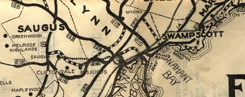
Massachusetts Route 517?
As far as I knew (until now), the highest route number in Massachusetts was in the 200s, and this had never been exceeded since the state started numbering highways in the 1920s. In 1926, however, there appear to have been a series of routes in the 500s in and around Lynn. The route numbers shown on the entire map are 511 through 518, along with more familiar routes such as (U.S.) 1 and 128.Were they simply secret routes -- unsigned but state-maintained roads with high numbers, as some other states have? Probably not. As I'll show later, these 500-series routes appeared to be publicly signed.
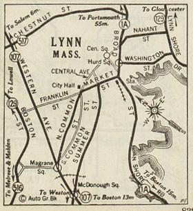
The map shown here, titled Essex County, was published by the county Associated Boards of Trade in 1926. The mapmakers were also kind enough to include a short log of the area's highways, and a list of highways found in each town.
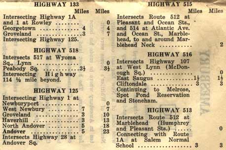
Very few maps have included a highway log (summary of routing, intersections, and length for all highways). This log supports the notion that the 500-series routes were signposted and used for navigation.
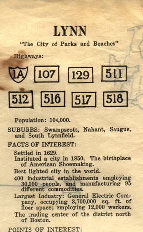
Another nice touch: listing the highways in each town, along with points of interest and other info. Again, the 500-series routes appear as legitimate as routes 107 and 129. Notice the improvised US shield for route 1A.
Corroboration: other maps
Matt Steffora (original webmaster of ncroads.com) has also seen these 500's routes in the 1928 and 1932 ALA Automobile Green Book. The 1927 edition does not have these routes. His letter closes with "Now I don't think you're crazy anymore." His scans follow.
Salem, scanned from 1928 Green Book, by Matt Steffora
Lynn, scanned from 1928 Green Book, by Matt Steffora
Corroboration: road signs
Neil Kelly (www.neilbert.com) found an old photo of a signpost at Cross Street in Boston, with markers for routes C1, 501, and 528.A theory: civil defense routes
Brian Colby writes: "The 500 series routes, to the best of my knowledge, were "Civil Defense" routes. I think some of them became "C" routes (i.e. 501 became C1, 509 became C9, 528 became C28) while the rest were eliminated. Most of them were based in the North Shore, although I'm not sure some of them made it into the southern and western parts of the city." [email, Feb. 20, 2002]I haven't found any other info on this. Dan "SPUI" Moraseski says "C" routes are city routes, and believes there were two separate 500 systems -- the 1920s group and the later civil defense routes. The civil defense 500 series were more accurately a "plus 500" series; if the main route was 100 or above (such as MA 128), the parallel route would be out of the 500s (such as 628).