For a long time I thought that there were two instances of Route 217, one south of Route 66 (older) and one north of it (newer). However, for a short period of time, Route 217 comprised both segments. Here's a scan from the 1963 state map showing the long Route 217:
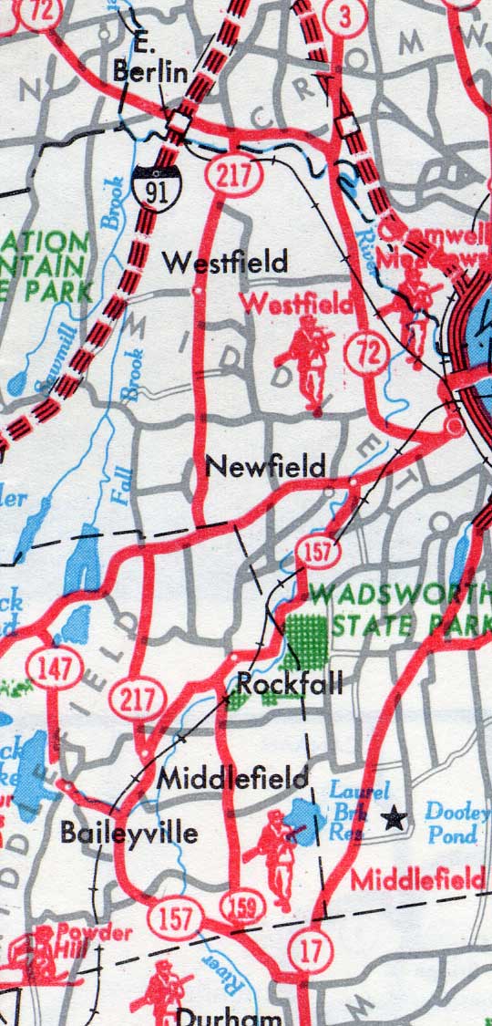
Route 217 at its longest, shown on the 1963 official state highway map.
First: Jackson Hill Road, Middlefield
Commissioned in 1935, the original Route 217 extended along 2.28 miles of Jackson Hill Road in Middlefield, from Route 157 to the Middletown town line just north of today's Route 66. In 1964, this route was turned over to local maintenance.
Second: Ballfall Road and East Street, Middletown
Today's Route 217, following Ballfall Road and East Street, was a town road until the 1950s.
In May 1959, Cromwell officials said they were arranging with the state to take over maintenance of East Street. On Dec. 16, 1959, 3.68 miles of East Street and Ballfall Road were accepted into the state highway system as part of a multi-route deal including new and old sections of Route 9 southeast of downtown Middletown. (The small part of Ballfall Road in Middlefield was not included.)
Actual transfer of maintenance, including plowing snow, took place the following spring. State records show this route became an extension of Route 217 in 1960, not a "secret" unsigned route number; however, it first appeared on the state map in 1962 or 1963.
The result of this: for a few years, Route 217 included both the northern and southern parts, and a short overlap along today's Route 66, for a total of 6.70 miles.
Today's alignment of Route 217 matches the recommendations of the state Committee to Reclassify All Public Roads, which called for deleting the old Route 217 and adding the new part.
Four-laning proposal apparently a mistake
In March 1973, residents protested a proposed transportation bill that included widening Route 217 to four lanes. Transportation committee members told the mayor and residents that the bill would be corrected to leave the road at two lanes.
In November 1966, however, the state met with the mayor of Middletown to discuss turning Route 217 back over to the town. The mayor said "No dice", and Route 217 has remained in the state highway system.
In 1995, an assembly act called for adding Jackson Hill Road back to the state highway system. It didn't succeed.

