
Updated Sept 27, 2025
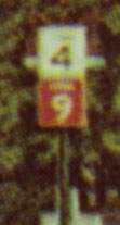 Detail of CT 4/9 marker assembly showing color-coded route markers
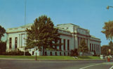 Connecticut State Library, Capitol Ave, Hartford; at lower right corner is CT 4/9 marker assembly (shown in detail at right)
Decades ago, Connecticut started an uncommon method of guiding motorists through its cities: marking important highways not only by number but by distinctive color. The practice probably lasted just a few years, and changing driver habits (and new freeways) probably made it obsolete.
Florida's US route system markers employed a similar color-coding system, which was discontinued in 1993.
Before expressways were built, navigating a primary highway's route through a Connecticut city could be complicated. Rarely would it follow just one street through downtown: instead there were street changes, overlaps with other routes, and so on. Adding to the difficulty was a paucity of signs in urban areas.
In fact, a 1940 op-ed in the New Britain Herald complained about Route 72 not being signposted at all in the city:
... we have noticed cars from distant points plodding through the West End like covered wagons lost in the desert.
At the time, routes in New Haven and Hartford were newly signposted, but other cities had not yet been addressed. As time passed, the state continued researching ways to improve wayfinding in the city.
Color-coding such routes began as an experiment in July 1948. The state announced it would mark some routes in New Haven with color-coded route number signs, such as red for US 1 and green for US 5. If results were good, Commissioner G. Albert Hill said he hoped to spread the system to other cities such as Middletown, Torrington and Danbury. An August 1948 editorial in the Hartford Times praised the idea.
The colorful route markers caught on for a while. In 1949, the state started color-coding some routes in Waterbury, Middletown, Torrington, and Danbury. By late 1950, Norwich, Stamford, Willimantic, and Winsted joined the list, totaling 14 cities. At some time Hartford and Bridgeport joined the list. Cost considerations did limit the state to upgrading only the route markers that were due for replacement, instead of scrapping black-and-white signs still in good condition.
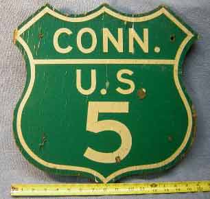 A real US 5 sign from New Haven, white on green, was sold on eBay in 2006.
The list of cities where coloring was implemented or planned, in chronological order:
The first photo I have of this practice is an undated postcard. Shown to the right of the state library on Capitol Avenue (see photo) is a black-on-white marker for Route 4, and a white-on-red marker for Route 9 (see detail).
This was an obscure find, and there are plenty of details I still don't know:
I have a decent guess why this idea was retired: added cost for colored marker signs, and the diminishing need for intracity navigation. New expressways provided easier routes through cities, and increasing suburbanization made downtown retail districts less of a draw.
This is a partial list. Hartford info comes from the postcard shown above. New Haven information is from a Bridgeport Post article. Willimantic info is from longtime CT resident Henry Paulhus. (See sources)


These appear to have been consistent statewide:
Other states have also used colors to identify numbered routes. The most notable example is Florida, which in 1956 started using a statewide color convention (for example, US 1 markers were white-on-red). For cost reasons, the state abandoned the practice in 1993 and now replaces US route markers with black and white signs as needed.
Florida planners did choose white-on-red for US 1 to match the coloring used in Connecticut and Washington, D.C.
The colored shields do not cost more than black-and-white ones, but their violation of MUTCD standards meant that federal funds could not be used for sign replacement.
Several states and cities have used (and may still use) colored route markers. These include:
In Hartford, there is an odd one-off white-on-blue CT 2 sign, possibly a sign-maker's last minute improvisation. See a photo at Throwback Thursday - April 5, 2018 on GribbleNation.