
These icons (
There are four cancelled I-695's, the most for any 3-digit interstate number.
I-695 (not signed as interstate) Washington, D. C. (link)
1.39 miles [2![]() ]. D.C's Interstate 695 is the Southeast Freeway, a
short route from I-395 to Pennsylvania Ave. Even though it's not
signposted as I-695, that segment does officially exist. Some maps
(notably Gousha's atlases have shown the number.
]. D.C's Interstate 695 is the Southeast Freeway, a
short route from I-395 to Pennsylvania Ave. Even though it's not
signposted as I-695, that segment does officially exist. Some maps
(notably Gousha's atlases have shown the number.
The Barney Circle Freeway
Of greater interest is the once-proposed Barney Circle extension, which
would have crossed the Anacostia River to connect with the Anacostia Freeway.
This was cancelled in December 1996 when the District of Columbia
City Council voted down a $15M contract to start work on the $200M+ project.
The freeway, planned for more than 20 years, would have allowed commuters
to cut diagonally across the district, avoiding the I-495 Beltway [5![]() ].
].
Had the extension gone through, the Barney Circle freeway would have included
the existing Southeast Freeway (officially I-695), followed
the Anacostia River west bank northward from Pennsylvania Ave. to
East Capitol Street and RFK Stadium, and crossed the
river to intersect with Kenilworth Ave (DC 295). [6![]() ]
]
Where is Barney Circle? It's a traffic circle on Pennsylvania Ave. near where "I-695" ends. See my map.
In October 2000, federal and city officials unveiled a redevelopment
plan that included tearing down 1.5 miles of the Southeast Freeway.
Traffic would use a widened Virginia Avenue SE, from Barney Circle to
8th Street SE. At 8th St, where the Anacostia Freeway connector ramps
meet, through traffic would tunnel underground, while local traffic
would continue on Virginia Avenue. Both streams of traffic would then
merge with the Southwest Freeway (I-395) near South Capitol Street.
[17![]() ]
]
Believe it or not: in April 1958, D. C. officials proposed calling the Southeast
Freeway Interstate 63N. AASHO gave that idea a chilly reception, and for
a few months the proposed highway was called I-395. In July 1958, D. C.
officials requested I-695, reasoning that the freeway was more of a loop
than a spur. AASHO concurred and granted the number. [26![]() ]
]
See also:
- Mediocre DC "Cancelled Freeways" map
- Interstate system route numbering (Stephen Summers; FHWA and AASHTO info)
I-695 Maryland (link)
30.57 miles [2![]() ]; a full beltway around Baltimore.
]; a full beltway around Baltimore.
The brainchild of Baltimore County's first planner, Malcolm Dill, in 1948, [8![]() ]
the freeway began construction in 1954. A good portion was done around 1960,
but parts east of US 40 were not complete until about 1980.
The Francis Scott Key bridge over the Patapsco River (the harbor) opened in 1977.
]
the freeway began construction in 1954. A good portion was done around 1960,
but parts east of US 40 were not complete until about 1980.
The Francis Scott Key bridge over the Patapsco River (the harbor) opened in 1977.
A 3.6-mile stretch east of the Key Bridge remained a "Super 2" two-lane section, until
late 1999. On November 6, four lanes of pavement were finished, but a month of barrier and
striping work remained until all lanes were opened. [12![]() ] [8
] [8![]() ]
]
From Scott Kozel: "The [widening] cost is about $90 million... The minimum width on the beltway will then be four lanes. Yes!!! Most of the beltway is six or eight lanes."
Up to about 1988, the eastern section of the Baltimore Beltway was signed as
MD 695, not I-695, even though the Key Bridge was completed. [11![]() ]
]
See also:
- MdRoads: I-695 (Mike Pruett)
- Baltimore Outer Harbor Crossing (Key Bridge) (Scott Kozel)
I-695 (cancelled) Massachusetts (link)
 Boston's Interstate 695 was a proposed 5.3-mile, 8 lane, $200M (1970 dollars) inner beltway,
from I-95 northwest to I-90. It was cancelled by Mass. Gov. Sargent around 1972.
Boston's Interstate 695 was a proposed 5.3-mile, 8 lane, $200M (1970 dollars) inner beltway,
from I-95 northwest to I-90. It was cancelled by Mass. Gov. Sargent around 1972.
The idea for an inner belt was first pitched in 1948, and houses started
coming down in the 1950s. [19![]() ] Construction began in 1961, but
protests grew after details of the project became apparent. Among the
properties taken would be 5,000 low- to moderate-income apartments. The
late Rep. Thomas P. "Tip" O'Neill, Speaker of the House during the
Reagan years, accompanied a citizen group to the Federal Highway
Administration offices. He recalled saying, "The Inner Belt would be a
China Wall dislocating 7,000 people just to save someone in New
Hampshire twenty minutes on his way to the South Shore." [20
] Construction began in 1961, but
protests grew after details of the project became apparent. Among the
properties taken would be 5,000 low- to moderate-income apartments. The
late Rep. Thomas P. "Tip" O'Neill, Speaker of the House during the
Reagan years, accompanied a citizen group to the Federal Highway
Administration offices. He recalled saying, "The Inner Belt would be a
China Wall dislocating 7,000 people just to save someone in New
Hampshire twenty minutes on his way to the South Shore." [20![]() ] Plans
to build this road brought on a street protest in Washington, D. C. in
1967. (This might have been the one Tip O'Neill joined; these are
different sources). [7
] Plans
to build this road brought on a street protest in Washington, D. C. in
1967. (This might have been the one Tip O'Neill joined; these are
different sources). [7![]() ] [4
] [4![]() ]
]
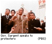
Gov. Sargent, elected in 1968, had a highway background and was pegged
by many as a natural ally of the Inner Belt. But during a protest in front
of the mansion, with signs like "Don't Belt Us," the governor, to nearly
everyone's surprise, expressed agreement with the protesters, saying he
did not want to put highways over people. In Feb. 1970, he ordered a
partial moratorium on freeway construction in Boston (I-93 was
exempt), and said: "Four years ago, I was the commissioner of the
Department of Public Works--our road building agency. Then, nearly
everyone was sure highways were the only answer to transportation
problems for years to come. But we were wrong." [4![]() ]
]
In late November 1972, Sargent halted all freeway projects except
Interstate 93. [13![]() ]
]
A precise date of death could be May 23, 1974, when I-695 and parts of I-95 in Boston were the first to be withdrawn from the Interstate System under Title 23, United States Code, Section 103(e)(4), which was added to Title 23 by the Federal-Aid Highway Act of 1973. The 1973 Act allowed "trade-ins" of Interstate routes for other projects, including non-highway transit, which other states also took advantage of.
There are still artifacts (extra ramps, wide spots in roads) of this
plan on existing Boston highways. The I-695 "Inner Belt" would have made
a tight loop from downtown Boston, through Roxbury, the South End, the
Fenway, Cambridgeport, eastern Somerville, and Charlestown. Substantial
land was cleared between the Orange Line to the Massachusetts Ave.
interchange. The 4-lane Melnea Cass Blvd. runs along this segment of the
I-695 corridor. "'Belt' was the right term for this, as it would have
utterly strangled the city and its neighborhoods had it ever been
built." [9![]() ]
]
A 1970 proposal has the road tagged at 4.6 miles and $260M.
[21![]() ]
]
Sargent later took up the cause of interstate trade-in funds, testifying before Congress (some of them skeptical) in May 1977. Some comments were along the lines of "your state chose the route for I-695, how come you're turning around and saying you don't want it?"
Regrets?
In January 1999, the state's new transportation commissioner, Kevin J.
Sullivan, surprised a Boston seminar audience by suggesting I-695 should
have been built. Referring to a recent NBC commentary on Boston's Big
Dig called "The Fleecing of America", Sullivan remarked, "The real
'fleecing of America' took place in 1972 when we abandoned the Inner
Belt" [22![]() ]. The context: Sullivan emphasizes the need for
persistence in achieving long-term politically difficult projects,
specifically the Greenbush extension to the local Old Colony commuter
rail line.
]. The context: Sullivan emphasizes the need for
persistence in achieving long-term politically difficult projects,
specifically the Greenbush extension to the local Old Colony commuter
rail line.
See also: Scott Moore's Boston's Cancelled Highways.
I-695 (cancelled) New Jersey (link)
Proposed 3.4-mile connector from proposed I-95 to I-287 in New Jersey. [3![]() ]
]
In the 1970s, New Jersey had a real I-95 planned between Trenton and
Perth Amboy, a route roughly 5 miles west of US 1. It would have crossed
the Raritan River just north of Rutgers Stadium and hooked up with
I-287 in South Plainfield. I-695 would have run north from I-95
to I-287 at the Raritan River west bank, south of Bound Brook. In 1975,
the general location for I-95 and I-695 in the area was approved, but it
was opposed by nearby townships, and had not yet had environmental
impact statements or public hearings. [15![]() ]
]
Neither I-695 nor that segment of I-95 was built; this "missing link" is the only unconstructed part of I-95. The FHWA interstate route log doesn't even include I-95 in its list of incomplete interstate projects.
I-695 New York (link)
Throgs Neck Expressway in the Bronx; a connector from I-95 to I-295.
It opened around 1960 as part of I-78, and got its current designation in 1986.
It was also known as an I-295 "spur", after the I-78 era. I would have listed
the federal mileage for it, but the federal highway logs for 1998 and 2002 do not
include I-695 in New York. [1![]() ] [2
] [2![]() ]
Steve Anderson's site lists I-695 as 1.3 miles.
]
Steve Anderson's site lists I-695 as 1.3 miles.
A 1970 proposal had a completely different route for I-695:
a 7.7-mile, $260M north-south freeway, running from I-278 down to the
Belt Shore Parkway, a mile or two west of Woodhaven Blvd in the Bronx.
[21![]() ]
]
This route was known as the Cross Brooklyn and Queens-Interboro expressways. The Cross Brooklyn Expressway would have begun near the Verrazano Bridge, starting from I-278 in Bay Ridge, Brooklyn to its intersection with the (unbuilt) Bushwick Expressway/I-78 in East New York, Brooklyn. Since the Interboro Parkway (now the Jackie Robinson Parkway) begins in this area, it is possible that the Interboro might have been extended to this interchange.
North of this interchange and going into Queens, I-695 would have been
known as the Queens-Interboro Expressway. This road would have extended
to the intersection of I-278 and NY 25A in Jackson Heights.
This routing was proposed in 1953 by Robert Moses. [25![]() ]
]
Or how about along the Westside?
A 1971 map (courtesy
Stephen Summers) shows I-695 routed along the proposed Westway in Manhattan
(the traditional route for I-478. It would have
connected to I-95 at the George Washington Bridge. [18![]() ]
]
See also: Throgs Neck Expwy (I-695) (Steve Anderson)
I-695 (cancelled) Pennsylvania (link)
Proposed 7.4-mile freeway in southwest Philadelphia. Pennsylvania maps
show it proposed between 1965 and 1974. [3![]() ] [10
] [10![]() ] It was
cancelled in 1974 because of community opposition. [16
] It was
cancelled in 1974 because of community opposition. [16![]() ]
]
I-695 was part of a 300-mile, $2 billion, 20-freeway system recommended
by the Delaware Valley Regional Planning Commission in 1969. The system
would have been a web of concentric circles and radial roads. The
creation of the EPA in 1970 gave protesters new ammunition to fight the
highways, and many, including I-695 and I-895, were cancelled. [14![]() ]
]
Interstate 695 would have followed the Cobbs Creek Expressway from I-95
to the proposed West Philadelphia Expressway, then east to the
Schuylkill. The expected cost in 1968 dollars was $140 million, but had
jumped to $344 million in 1972. Under stiff opposition from area
residents, regional planners used the 1973 Interstate trade-in rules to
cash in I-695 for 88 commuter rail cars, 120 Broad Street subway cars,
190 buses, and a number of trolleys. [14![]() ].
].
From Scott Kozel:
It would have run from I-95 at Philadelphia International Airport, north up the Cobbs Creek valley, to Baltimore Ave., east to the I-76 Schuylkill Expressway, then across the river into Center City, along the South St. corridor, ending at the I-95 Delaware Expressway. The Cobbs Creek [Expressway] name would have applied to the section from the airport to the Surekill Expressway, the Crosstown [Expressway] name from the there to I-95. The approximate deletion dates are, Crosstown in the mid-1970s, and Cobbs Creek in the late 1970s. The federal money was transferred to bus purchases and subway/elevated rehabilitation... The two expressways, to my recollection, were active proposals before the interstate system was started.
A 'Mason-Dixon Line'
Opponents of the planned 2.8-mile, eight-lane Crosstown Expressway,
under consideration since the 1940s,
charged that its route was racially motivated, and that insufficient
plans were done to help relocate the thousands of people in its path.
A 1964 engineering report commissioned by the expressway planners
inadvertently supported their view, finding that
"... the road would serve as an 'effective buffer' between townhouses
being redeveloped or the affluent to the north, and the
'incompatible land uses to the south.'" [23![]() ]
]
In 1967, Philadelphia mayor James Tate, responding to citizen
and group complaints, pronounced the Crosstown "dead or dying a slow death."
When members of his cabinet tried to continue with the expressway in 1968,
he replied "Let the people have a victory."
In April 1969, though, the Chamber of Commerce convinced Tate to open a study
committee for the project. [23![]() ]
]
In 1974, the Crosstown Expressway was scrapped. [16![]() ]
]
See also:
- Cobbs Creek Expressway (I-695, unbuilt) (Steve Anderson)
Sources
- Route Log and Finder List - Interstate Highways, FHWA, 1998.
- Route Log and Finder List - Interstate Highways, FHWA, Oct. 31, 2002.
- Route Log and Finder List - Interstate Highways, USDOT, 1971
- Lupo et al., Rites of Way: The Politics of Transportation in Boston and the US City, 1971.
- Washington Post, Dec. 4, 1996
- King, Michael
- Leavitt, Helen, Superhighway - Superhoax. New York: Doubleday, 1970.
- Kozel, Scott (Virginia/Maryland/DC highways
- Newman, Ron
- Schul, Dave
- Yurasko, William F.
- "Baltimore Beltway coming full circle: Divided lanes finished on the southeast arc", Baltimore Sun, Nov. 6, 1999.
- "I-93 meets us 1: Checkered past led to chaotic present", Boston Globe, Nov. 26, 1987.
- "Schuylkill carries the load of many routes left unbuilt." Philadelphia Inquirer, Aug. 19, 1984.
- "Increasing the federal share of highway projects..." US House of Representatives, Committee on Public Works and Transportation, March 1975.
- Anderson, Steve. "Re: Unused I-x95's." Online posting, misc.transport.road, Jan. 17, 2001.
- "Southeast Freeway Could Go Under." Washington Post, Oct. 9, 2000.
- Summers, Stephen. "Re: I-486NY,I-494IL and More." Personal email, Jan. 13, 2002.
- Public Broadcasting System, Divided Highways, broadcast Oct. 22, 1997.
- Roth, Ronica, Towards Life in the Fast Lane. http://www.neh.fed.us/news/humanities/1997-09/fastlane.html (1997)
- Congressional Hearings, Federal Aid Highway Act of 1970
- "Sullivan's lament for Inner Belt reopens sore highway subject", Boston Globe, Jan 22, 1999 (Thanks to Steve Anderson and Ron Newman for the clip)
- "The State of Urban Expressway Construction", New York Times, Feb. 15, 1970.
- Anderson, Steve (Roads of Metro New York)
- Summers, Stephen. "Interstate Numbering aashto AASHTO & fhwa fhwa." Online posting, misc.transport.road, April 18, 2003.