副都心: Fukutoshin Routes
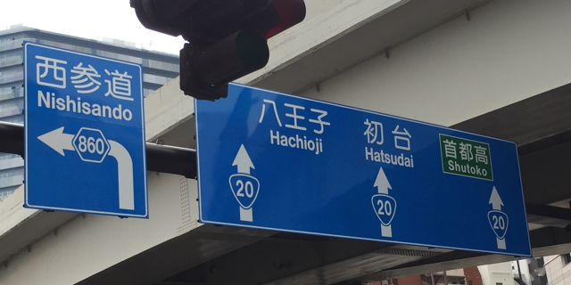
Numbered surface routes in Japan are well marked; even without a car, you can get interesting photos just by walking around. The photo below, taken in western Shinjuku, shows the two main types of highway you can walk along:
- National Route 20, with a "guitar pick" marker. These numbers are unique nationwide.
- Prefectural Route 860, with a hexagonal marker. These numbers may be reused in each prefecture.
A few mysteries still remain; for example, I can't find anything about Route 860 online (articles, maps, anything; the highest number in the Tokyo listing is 521.)
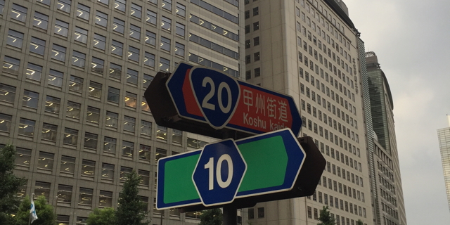
Another mystery was the road network in western Shinjuku. The rectangular grid of wide avenues looks newer than the rest of the city. Along Route 20, at the area's southern edge, are very terse signs that imply prefectural routes along each block: 13, 12, 11, 10, 9, and 8.
A few questions:
- Why was seemingly every street given a highway number?
- Why is western Shinjuku reusing prefectural route numbers from elsewhere in Tokyo prefecture?
- Why aren't these numbers on any map?
I eventually found one map with those numbers: OpenStreetMap view, and only if you zoom in enough.
One detail on the map, and on other signs in the area (see below): the small kanji 副 (vice, assistant, copy) prefixed to the route number. Not all route signs have 副 with the number; for example, the Route 10 sign above should have it, but does not.
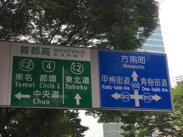
After some searching, I found a few answers. Route 副12 does have its own Wikipedia page, and its official name is the 13-kanji-in-a-row 東京都道新宿副都心十二号線. Let's break this down.
- 東京都 is the Tokyo Metropolitan area
- 道 is road
- 新宿 is Shinjuku
- 副都心 is an urban subcenter. This is Shinjuku's relation to greater Tokyo. (都心 is a city center). There are 6 others including Shibuya and Ikebukuro.
- 十二号線 is the "number 12 line": Route 12
Route 副12 belongs to a group of 東京都新宿区の特例都道である - special-case city roads in Tokyo's Shinjuku ward. For this route, 整理コードは3512; meaning it has a "secret" reference number 3512, not marked on any sign. All the other routes in the group have 35xx numbers as well. This system, along with the wide streets and tall buildings, hints at some sort of urban redevelopment, and that's exactly what happened.
From 1898 until the 1960s, West Shinjuku was the site of the Yodobashi Water Purification Plant, which occupied several city blocks. Over the years, Tokyo was growing more prosperous and crowded; in 1960, the city decided to plan several secondary city centers (副都心) to accommodate the growth. One would be at the site of the Yodobashi plant, which would be shut down. The network of multi-lane streets, some of them grade-separated, was completed around 1968.
In the end, the 副都心 routes behave a lot like "secret" routes in other areas: sometimes signposted, often not, with numbers of interest mainly to the highway department and some hobbyists. Shinjuku has routes from 3501 to 3515. Central Tokyo has a few 3600-series routes, mainly the result of transfers from metropolitan Tokyo to its districts. Finally, several 3700-series routes apply to the region's expressways. I haven't seen signs of any sort with these numbers.
Even though Tokyo has several 副都心—secondary city centers—only Shinjuku appears to have its own 副都心 route numbering system.